Customer Reviews
No reviews have been written for this product.
- Related Products -
-
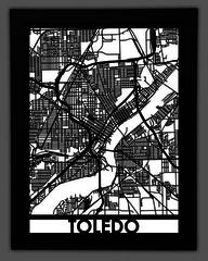 Toledo $239.99SHOP NOW
This map of Toledo, Ohio contains all of the historical sites and modern attractions that give this city it’s Midwestern charm. Whether it’s Imagination Station or the Toledo Zoo, this map displays all of the elements that make this city truly unique!
Divided by I-75, this map contains the city’s downtown area west of the Maumee River. From Polish Village to Ottowa Park, point out streets you’ve lived on, and places you’ve been to with this real city street map of Toledo, Ohio.
Our 18”x24” maps are made from High Density EVA foam and are precision cut using laser cutting technology to create a beautiful work of art for your home.
The 34”x36” Wooden maps are cut from ¼” walnut plywood using CNC machinery and are ready to hang for friends and family to enjoy.
Check out these related maps! -
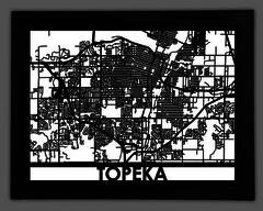 Topeka $239.99SHOP NOW
This map of downtown Topeka, Kansas contains all of the historical sites and modern attractions that give this city it’s western charm. Whether it’s the Old Prairie Town or Gage Park, this map displays all of the elements that make this city truly unique!
Situated on the Kansas River, this map contains the city’s downtown area. From Bellview to Rock Hill, point out streets you’ve lived on, and places you’ve been to with this real city street map of Topeka, Kansas.
This map of Topeka is made from a solid piece of stainless steel and is precision cut to create a beautiful work of art for your home! All of our stainless steel maps come framed and ready to be put on display for your family and friends to enjoy.
Our 18”x24” maps are made from High Density EVA foam and are precision cut using laser cutting technology to create a beautiful work of art for your home.
The 34”x36” Wooden maps are cut from ¼” walnut plywood using CNC machinery and are ready to hang for friends and family to enjoy. -
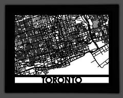 Toronto $239.99SHOP NOW
This map of downtown Toronto, Ontario contains all of the historical sites and modern attractions that give this city it’s vibrant character. Whether it’s the St. Lawrence Market or the Distillery District, this map displays all of the elements that make this city truly unique!
Situated on Lake Ontario, this map contains the Metropolitan area north east of High Park. From Old Toronto to the CN Tower, point out streets you’ve lived on, and places you’ve been to with this real city street map of Toronto, Ontario.
Our 18”x24” maps are made from High Density EVA foam and are precision cut using laser cutting technology to create a beautiful work of art for your home.
The 34”x36” Wooden maps are cut from ¼” walnut plywood using CNC machinery and are ready to hang for friends and family to enjoy.
-
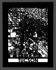 Tucson $239.99SHOP NOW
This map of Tucson, Arizona contains all of the historical sites and modern attractions that gives this city it’s rich southwestern character. Whether it’s the University of Arizona or the Titan Missile Museum, this map displays all of the elements that make this city truly unique!
Divided by I-10 this map contains the Metropolitan area set in the Sonoran Desert. From the Rillito River to Lincoln Park, point out streets you’ve lived on, and places you’ve been to with this real city street map of Tucson, Arizona.
Our 18”x24” maps are made from High Density EVA foam and are precision cut using laser cutting technology to create a beautiful work of art for your home.
The 34”x36” Wooden maps are cut from ¼” walnut plywood using CNC machinery and are ready to hang for friends and family to enjoy. -
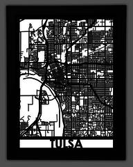 Tulsa $239.99SHOP NOW
This map of downtown Tulsa, Oklahoma contains all of the historical sites and modern attractions that give this city it’s rich character. Whether it’s the Golden Driller or the Center of the Universe this map displays all of the elements that make this city truly unique!
Divided by I-244, this map contains the metropolitan west of the Arkansas River. From Riverside Drive to the Greenwood Historic District, point out streets you’ve lived on, and places you’ve been to with this real city street map of Tulsa, Oklahoma.
Our 18”x24” maps are made from High Density EVA foam and are precision cut using laser cutting technology to create a beautiful work of art for your home.
The 34”x36” Wooden maps are cut from ¼” walnut plywood using CNC machinery and are ready to hang for friends and family to enjoy. -
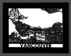 Vancouver $239.99SHOP NOW
This map of Vancouver, British Columbia contains all of the historical sites and modern attractions that give this city it’s bustling seaport charm. Whether it’s the beautiful Stanley Park or the Granville Island, this map displays all of the elements that make this city truly unique!
Centered on the Burrard Inlet, this map contains the metropolitan area east of English Bay. From Yaletown to Kitsilano Beach, point out streets you’ve lived on, and places you’ve been to with this real city street map of Vancouver, Canada.
Our 18”x24” maps are made from High Density EVA foam and are precision cut using laser cutting technology to create a beautiful work of art for your home.
The 34”x36” Wooden maps are cut from ¼” walnut plywood using CNC machinery and are ready to hang for friends and family to enjoy. -
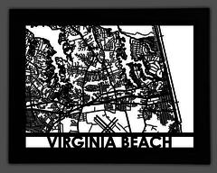 Virginia Beach $239.99SHOP NOW
This map of Virginia Beach, Virginia contains all of the historical sites and modern attractions that give this city it’s sea side charm. Whether it’s the First Landing State Park or the Virginia Beach Oceanfront, this map displays all of the elements that make this city truly unique!
Focused on Little Neck Creek, this map contains city’s downtown area. From Hilltop to US-60 point out streets you’ve lived on, and places you’ve been to with this real city street map of Virginia Beach, Virginia.
Our 18”x24” maps are made from High Density EVA foam and are precision cut using laser cutting technology to create a beautiful work of art for your home.
The 34”x36” Wooden maps are cut from ¼” walnut plywood using CNC machinery and are ready to hang for friends and family to enjoy. -
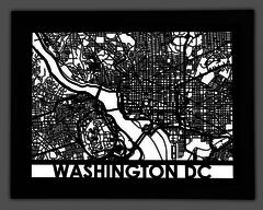 Washington DC $239.99SHOP NOW
This map of Washington, DC contains all of the historical sites and modern attractions that make this city the Nation’s Capital. Whether it’s the National Mall or Ford’s Theater, this map displays all of the elements that make this city truly unique!
Divided by the Potomac River, this map contains America’s capital south of Rock Creek Park. From Arlington National Cemetery to the White House, point out streets you’ve lived on, and places you’ve been to with this real city street map of Washington, DC.
Our 18”x24” maps are made from High Density EVA foam and are precision cut using laser cutting technology to create a beautiful work of art for your home.
The 34”x36” Wooden maps are cut from ¼” walnut plywood using CNC machinery and are ready to hang for friends and family to enjoy.
- Other Products -
-
 Butterflies $17.95Like the beautiful butterflies are transformed into nature, change your space with this gobo icon of beauty , prosperity and movement.SHOP NOW