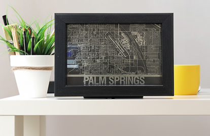
Custom Maps
GET YOUR 5"X7" CUSTOM STAINLESS STEEL MAP.
Whether it’s your hometown, a memorable trip, or a special location, we’ll bring your map to life in stainless steel.
Email us at support@machineartist.com for custom requests.
Custom Stainless Steel Map
$125.00


- Related Products -
-
 Stencil Initials $50.00Add a modern touch to your wedding with the Stencil Initials animated digital monogram! This sleek, stylish template features your initials, names, and wedding date in a contemporary design that’s perfect for a trendy event.SHOP NOW
 -
 Modern Ornament $50.00An elegant and charming way to enhance your celebration with the Modern Ornament animated digital monogram! This template showcases beautifully the couple's names and wedding date, artfully displayed in a classic style.SHOP NOW
 -
 Love Ring Animated $50.00Celebrate your love with the Love Ring animated digital monogram! This romantic template features a beautiful ring along with the couple’s names, symbolizing unity and commitment.SHOP NOW
 -
 Wedding Sweetie $50.00Bring a sweet, whimsical touch to your wedding with the Wedding Sweetie animated digital monogram! This charming template features playful accents that create a warm and inviting vibe.SHOP NOW
 -
 Capture your favorite places in timeless stainless steel. Each map is precisely cut and finished for a sleek, modern look that makes a perfect gift or statement piece.SHOP NOW